Walk: San Vigilio - Lé dla Creda

San Vigilio - San Martin
Add to favourites
Category
Difficulty
Easy
Duration
0:58
in hours
Distance
3.5
in km
Suggested period
Jan
Feb
Mar
Apr
May
Jun
Jul
Aug
Sep
Oct
Nov
Dec

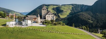
Either from the village square via Valiares or from the Aqua Bad Cortina Oasis Hotel, follow the Tres La Val trail up to the Spiaggetta Ciamaor park. Heading towards Tres La Val, walk on the right side of the stream starting from the Spiaggetta Ciamaor park and continue on to the next bridge just before Lé dla Creda. From there, it is another 10 minute walk. The route back to San Vigilio leads partly along the main road and partly along the walkway.

Route data
Easy
Distance
3,5 km
Duration
58 min
Ascent
86 m
Decent
17 m
Physical condition
Scenary
Highest point
1.272 m
Lowest point
1.202 m
You might be interested in
Discover related tours
Pice Ju | © Obwegs Carlo, St. Vigil in Enneberg
Intermediate
Add to favourites
San Vigilio - San Martin
Hike around Pice Ju
Distance 2,7 km
Duration 1 h 15 min
Ascent 140 m
Decent 140 m
San Vigilio - San Martin
Lungiarü to the Val di Murins
Distance 1,7 km
Duration 2 h 00 min
Ascent 159 m
Decent 5 m
Malga Vaciara | © AT San Vigilio San Martin, St. Vigil in Enneberg
Intermediate
Add to favourites
San Vigilio - San Martin
Summer hike: Lungiarü - Val di Murins - Vaciara
Distance 7,1 km
Duration 2 h 50 min
Ascent 782 m
Decent 81 m
Status
closed
Peitlerkofel | © Ass. turistica San Martin, St. Vigil in Enneberg
Intermediate
Add to favourites
San Vigilio - San Martin
Passo delle Erbe - Peak Putia
Distance 5,7 km
Duration 3 h 03 min
Ascent 936 m
Decent 52 m
Status
closed
Pütia | © Associazione Turistica San Martin de Tor, St. Vigil in Enneberg
Intermediate
Add to favourites
San Vigilio - San Martin
Summer hike: Passo delle Erbe - Forcella di Putia
Distance 3,8 km
Duration 1 h 30 min
Ascent 415 m
Decent 52 m
Status
closed
Ütia Fornella | © Ass. turistica San Martin, St. Vigil in Enneberg
Intermediate
Add to favourites
San Vigilio - San Martin
Hut-tour Antermoia
Distance 16,7 km
Duration 5 h 26 min
Ascent 996 m
Decent 1.020 m